


Tagofy Tagofy
Category
PhotographyTag
GPS Camera | Geotagging | GPS Location | Time Stamping | QR Code Scanning
Rate
4.20
★★★★★
Reviews
500 +
Installs
10M +
Developer
Vasundhara Infotech LLP
Content Rating
Everyone
Capture & tag moments with timestamps in your photos with a GPS Map Camera.
 4.20
4.20 Advertisements
Advertisements
Author's Review
appspicked Review
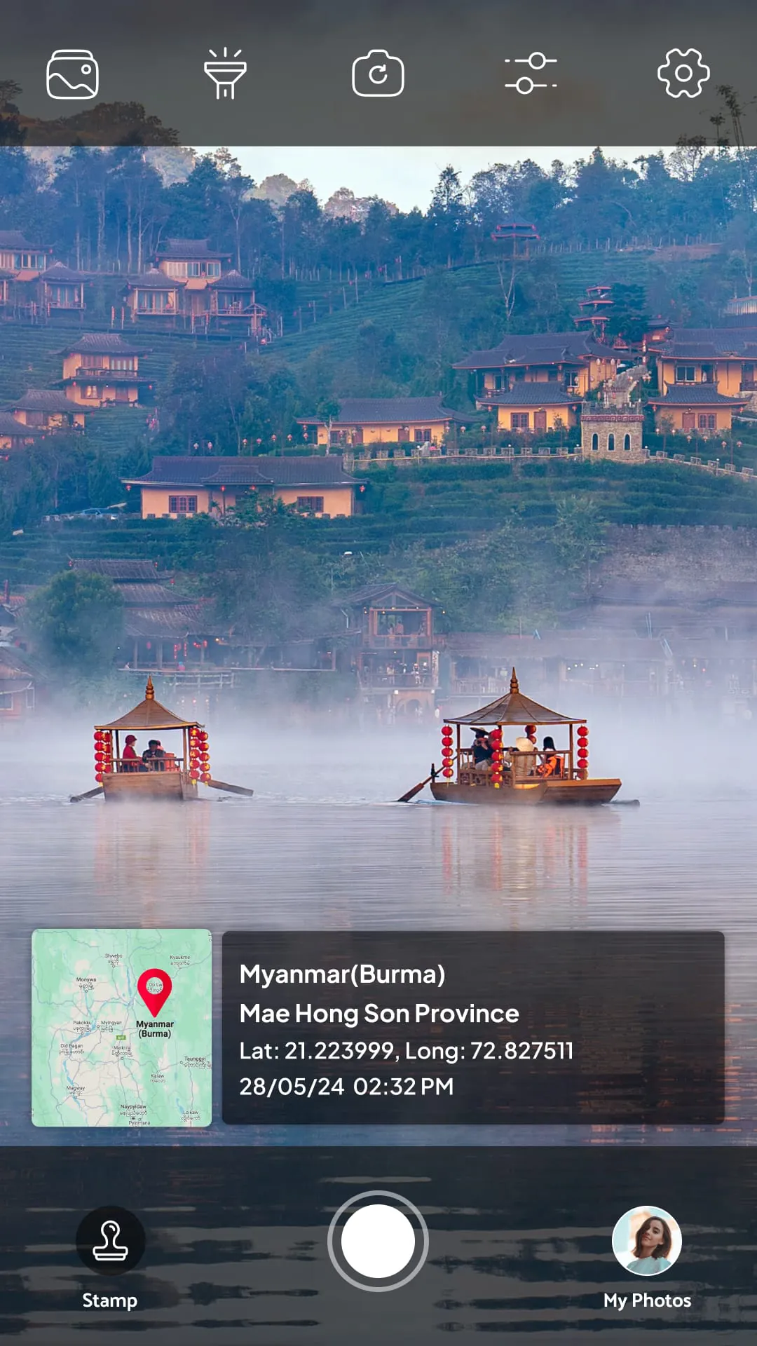
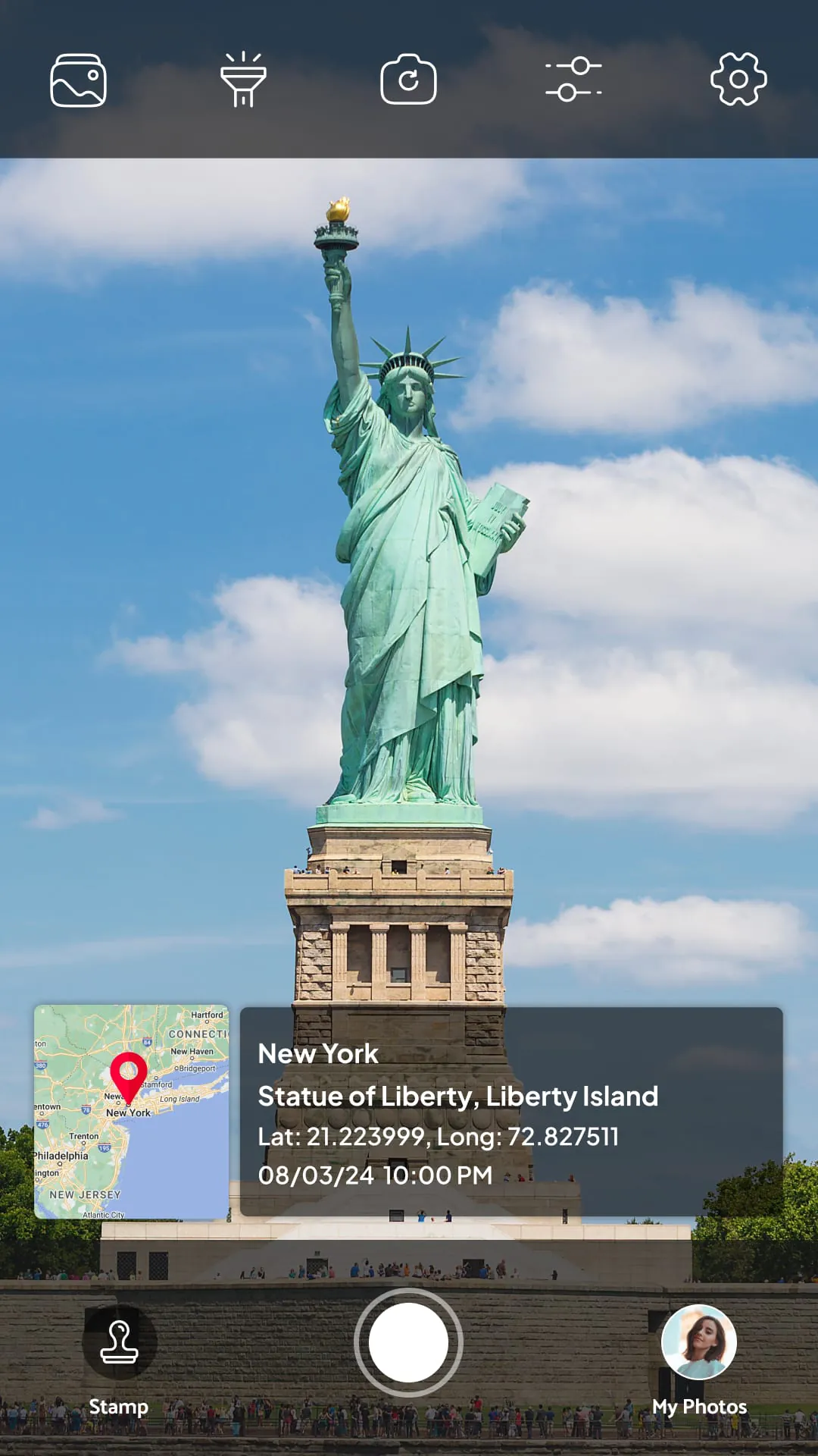
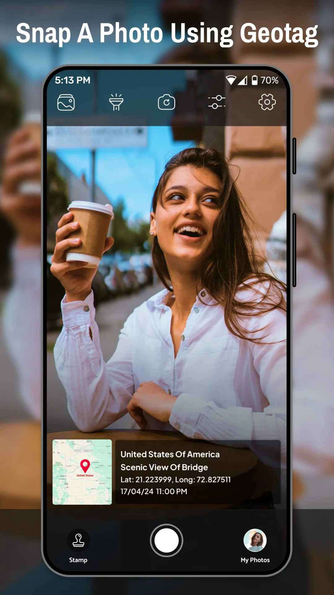
Tagofy - Geotag GPS Camera emerges as an indispensable application for photography aficionados and professionals alike, offering a robust suite of features designed to enhance the photographic experience through the integration of GPS location data, precise timestamps, and versatile geotagging capabilities. This application transcends the limitations of conventional photography by embedding crucial contextual information directly into each image, transforming static photographs into dynamic records of time, place, and circumstance. At its core, Tagofy is engineered to seamlessly overlay GPS coordinates, date and time stamps, and customizable location tags onto every photograph captured, ensuring that users can perpetually recall the exact moment and geographical setting in which their memories were immortalized. The app's intuitive GPS camera interface and potent geotagging functionalities collectively elevate both the photographic process and the subsequent exploration of captured memories, making it an invaluable asset for travelers, explorers, field researchers, and anyone who values the confluence of photography and location-based data. By enabling users to capture and preserve not only visual representations but also the precise spatial and temporal context of each image, Tagofy fosters a deeper connection between the photographer, the subject, and the environment in which the photograph was taken. The app's capacity to embed GPS location, latitude, longitude, address, date, and time stamps on camera photos using advanced geotagging technology ensures a comprehensive and accurate record of each moment, enriching the storytelling potential of every image. Whether documenting personal adventures, professional projects, or scientific observations, Tagofy provides a seamless and reliable means of associating photographs with their corresponding geographical and temporal data, thereby transforming the act of photography into a powerful tool for documentation, analysis, and recollection. Moreover, the ability to customize GPS photo stamps allows users to tailor the information displayed on their images, emphasizing specific details such as date, time, map coordinates, latitude, longitude, altitude, weather conditions, magnetic field data, and compass orientation, along with the option to integrate QR codes for enhanced data capture and accessibility. This level of customization ensures that each photograph not only captures a visual moment but also serves as a comprehensive record of the surrounding environment and contextual information. Tagofy's integration of QR code scanning functionality further expands its utility, enabling users to seamlessly capture and embed QR codes directly into their GPS-tagged photographs. This feature is particularly valuable for professionals engaged in field surveys, property documentation, work reports, and travel logs, as it allows for the efficient capture and association of supplementary data with each image. The scanned QR codes can contain a wide range of information, from product details and website links to contact information and survey responses, thereby enriching the photographic record with additional layers of context and meaning. In essence, Tagofy empowers users to transform their photographs into dynamic, data-rich records that capture not only the visual essence of a moment but also the critical contextual information that defines its significance.
The core functionality of Tagofy revolves around its ability to seamlessly embed GPS coordinates, timestamps, and geolocation data directly into camera photos, ensuring unparalleled accuracy in preserving the context of each captured moment. This feature is particularly beneficial for users who seek to meticulously document their travels, outdoor adventures, or professional projects, as it allows them to effortlessly track and revisit past locations with GPS-stamped photos. The GPS timestamp camera effectively transforms the photo gallery into a chronological timeline of experiences, enriching each snapshot with meaningful details pertaining to time and location. By capturing real-time GPS location, timestamps, and navigation data, Tagofy transcends the limitations of conventional photography, offering users a comprehensive tool for both personal and professional applications. The app's seamless GPS geotagging capabilities ensure that every photograph is accurately associated with its corresponding geographical coordinates, allowing users to easily track their movements, identify points of interest, and revisit memorable locations with precision. Whether exploring remote wilderness areas, navigating bustling urban landscapes, or conducting field research in diverse environments, Tagofy empowers users to capture and preserve the spatial context of their experiences, transforming their photographs into interactive maps of their journeys. Furthermore, Tagofy's capacity to document more than just images extends its utility beyond mere visual representation. By capturing real-time GPS location, timestamps, and navigation data, the app provides users with a comprehensive record of their movements and surroundings, enabling them to analyze their travels, track their progress, and share their experiences with others in a meaningful and informative way. This feature is particularly valuable for professionals who require accurate and reliable documentation of their field activities, such as surveyors, environmental scientists, and construction workers, as it allows them to seamlessly integrate GPS data into their work reports and project documentation. The integration of QR code scanning further enhances Tagofy's versatility, enabling users to capture and save QR codes directly onto their GPS-tagged camera photos. This feature is particularly useful for field surveys, property documentation, work reports, and travel logs, as it allows users to quickly and easily associate additional information with their images. For example, a surveyor could use Tagofy to capture a photograph of a property and simultaneously scan a QR code containing the property's address, legal description, and other relevant details. Similarly, a construction worker could use Tagofy to document the progress of a project and scan QR codes containing information about materials, equipment, and safety procedures. By seamlessly integrating QR code scanning into its GPS-tagging capabilities, Tagofy provides users with a powerful tool for capturing and organizing information in a variety of settings.
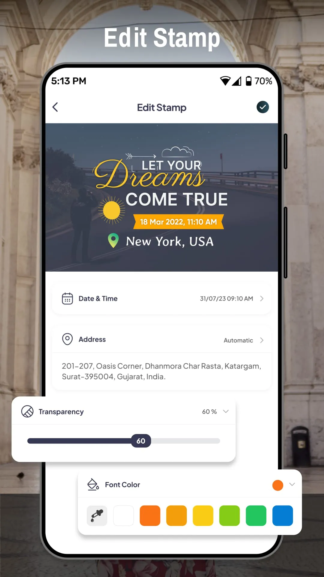
Tagofy distinguishes itself from conventional photo applications through its emphasis on enhancing user experiences with detailed GPS geotags and timestamps, thereby transforming photographs into comprehensive narratives enriched with geolocation data. The application facilitates the exploration and sharing of GPS-stamped photos, enabling users to confidently present their outdoor adventures, business trips, and travel experiences with the backing of precise location and time information. This feature is particularly valuable for individuals who wish to share their experiences with others, whether through social media, online travelogues, or professional presentations, as it allows them to provide their audience with a clear and accurate understanding of the context in which the photographs were taken. By preserving the past and organizing the future with GPS photo tags, Tagofy bridges the gap between photo memories and future travel plans, enabling users to document, relive, and plan using GPS-stamped images. The application's accurate GPS-based timestamping and geotagging capabilities ensure that every photograph is precisely associated with its corresponding location and time, allowing users to easily search, filter, and organize their images based on geographical and temporal criteria. This feature is particularly useful for users who have large collections of photographs, as it enables them to quickly locate specific images based on when and where they were taken. Furthermore, Tagofy's automatic GPS location tagging for travel photography streamlines the process of capturing and organizing travel memories, enabling users to focus on enjoying their experiences without having to manually tag each photograph with location information. The application's customizable GPS camera photo stamps and overlays provide users with the flexibility to tailor the information displayed on their images, allowing them to highlight specific details such as date, time, coordinates, and location names. Tagofy offers multiple timestamp and GPS map templates, catering to diverse user preferences and aesthetic styles, ensuring that users can customize the appearance of their GPS-stamped photos to match their individual tastes. The quick access to all GPS location-tagged photos further enhances the user experience, enabling users to easily browse, share, and manage their geotagged images. Tagofy's ability to seamlessly share geotagged GPS camera photos with family, friends, and colleagues fosters connection and collaboration, allowing users to share their experiences and insights with others in a meaningful and informative way. Whether capturing travel adventures, professional reports, real estate properties, or outdoor explorations, Tagofy ensures that every photo tells a complete geolocation-based story, enriching the photographic record with valuable contextual information. As an essential GPS camera tool for travelers, explorers, professionals, and storytellers, Tagofy transcends the limitations of conventional photography, empowering users to capture and preserve their memories with unparalleled precision and detail. Wherever life takes you, Tagofy enables you to make your photos unforgettable with GPS geotagging and QR code integration, transforming them into dynamic and informative records of your experiences.
Advertisements
Advertisements
Screenshots
 Download
 Additional Information
Category
PhotographyVersion
Unknown
Tag
GPS Camera | Geotagging | GPS Location | Time Stamping | QR Code Scanning
Rate
4.20
★★★★★
Reviews
500 +
Installs
10M +
Developer
Vasundhara Infotech LLP
Content Rating
Everyone
Capture & tag moments with timestamps in your photos with a GPS Map Camera.
Previous Versions
ZIP files require a Split APKs Installer (e.g., SAI) from Google Play to install. Steps: 1. Download SAI from Google Play; 2. Open SAI and tap "Install APKs"; 3. Select the ZIP file; 4. Complete installation.
You Might Like


Advertisements